A Sampling of the Weather Data Taken at the James Clerk Maxwell Telescope
Eric Silverberg
September 12, 1997
Abstract
This memo uses the weather data taken by the operators of the James C. Maxwell Telescope (JCMT) to draw a number of inferences about the future environment of the SMA in MM Valley. As expected, the data confirms that the SMA can expect to encounter temperatures primarily between 0C and 10C at all times of the year. Winds over 60 mph are rare at this location and occur almost always from an azimuth of about 260 deg. High humidity conditions only occur when the temperature is below 10 C. The surface measurements do not allow a reliable calculation of the relative opacity above the site.
Introduction
The SMA control building on Mauna Kea (MK) is about 150 meters from the JCMT, an installation that has been running for many years. The JCMT has, for some time, recorded temperature, wind speed, wind direction and humidity from the top of a weather tower, nearly equidistant from it and the SMA. In June of 1997 their staff kindly allowed us to download the last 3.5 years of weather data in the form of 15-minute averages. The data appears to be very nearly continuous since 1994 and provides the only record, to our knowledge, of the conditions in MM Valley as opposed to those at the summit. (Minute by minute readings are also available in the JCMT archives for the very diligent investigator.) While 3.5 years is too short an interval to make any sweeping claims, it does give us an excellent snap shot of the environment near the SMA inner ring. A number of examples have been selected from this data set to illustrate the conditions under which the SMA must operate.
Temperature and Humidity
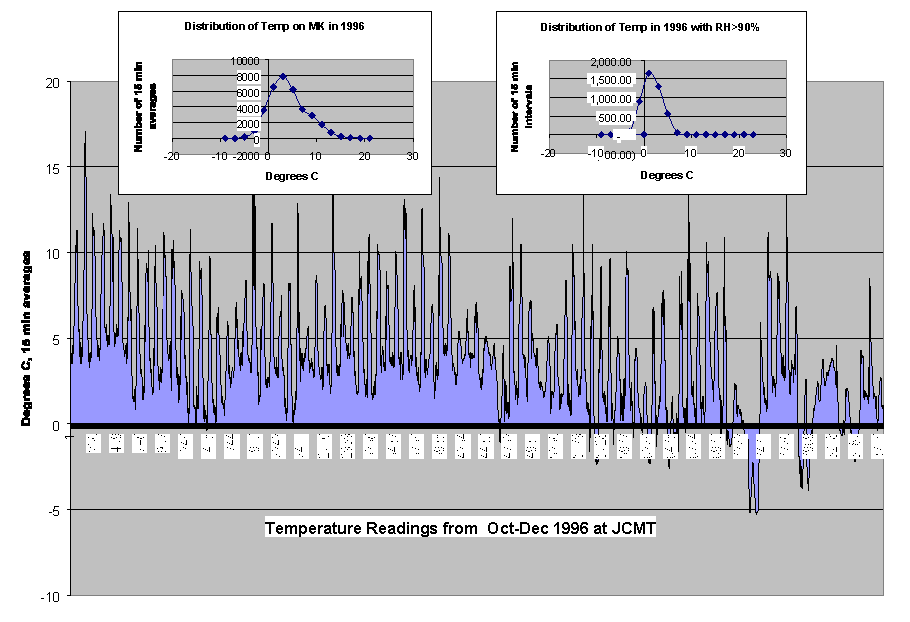
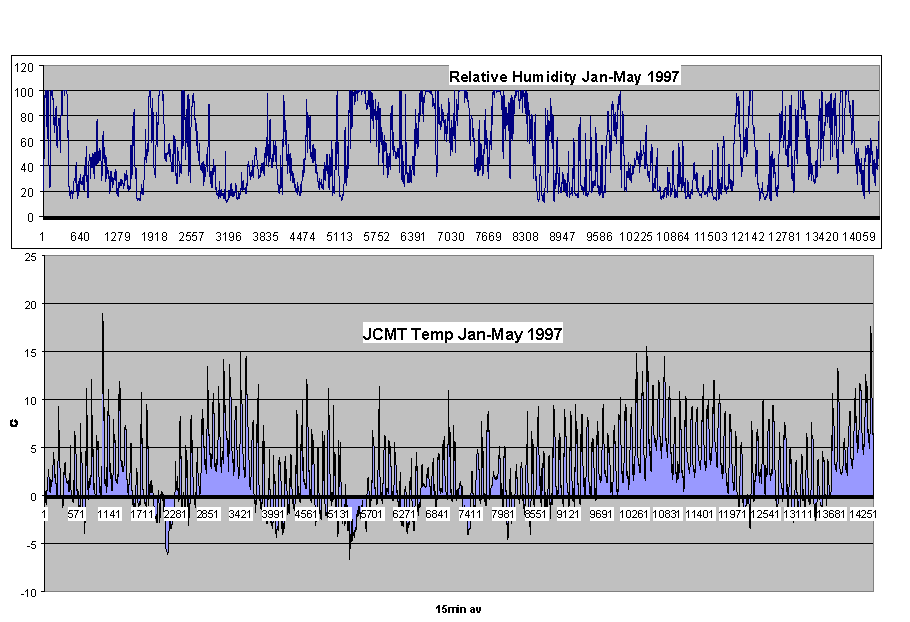
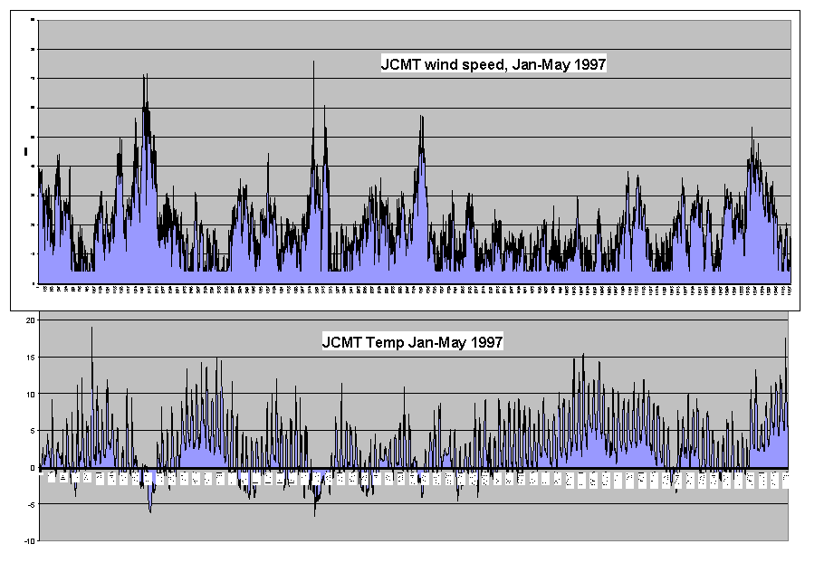
Chart 4 and Chart 5 show examples of the raw temperature readings over the last year. Note that the diurnal range is very small, as are the annual fluctuations. The 1996 record on Chart 4 tracks the day by day fluctuations from a very moderate fall climate to one of the worst periods in recent years. Even so, the changes are small by comparison with most sites. Inserts on Chart 4 and illustrate this range by showing the frequency distribution of temperatures for the year. In all cases these data refer to the 15-minute averages.
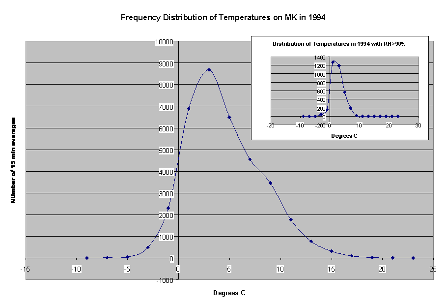
A sampling of the raw humidity readings is also illustrated on Chart 5. Here we do have very large fluctuations. These data have also been summed to show the temperature frequency of all instances when the humidity was above 90%. It is interesting to note that when the humidity is high the temperature is low. You can see this from the insert on Chart 5 and again on Chart 6, the latter of which shows the same frequency distributions for all of 1994.
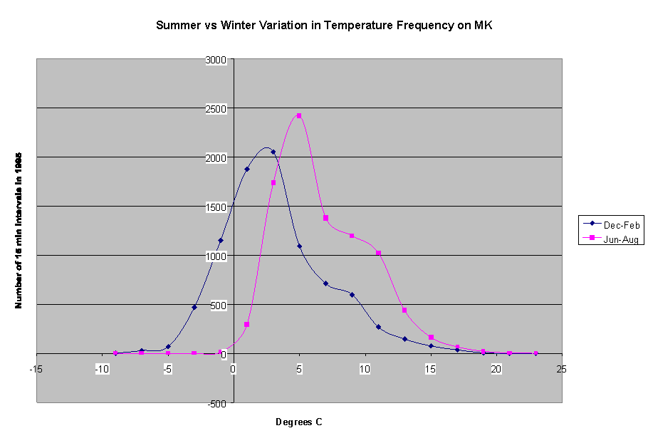
To further illustrate the seasonal variations, the winter and summer months were compared for 1995, see Chart 7. Note that while it is uncommon to freeze in mid summer, all other temperature conditions can be found at any time of year.
Wind
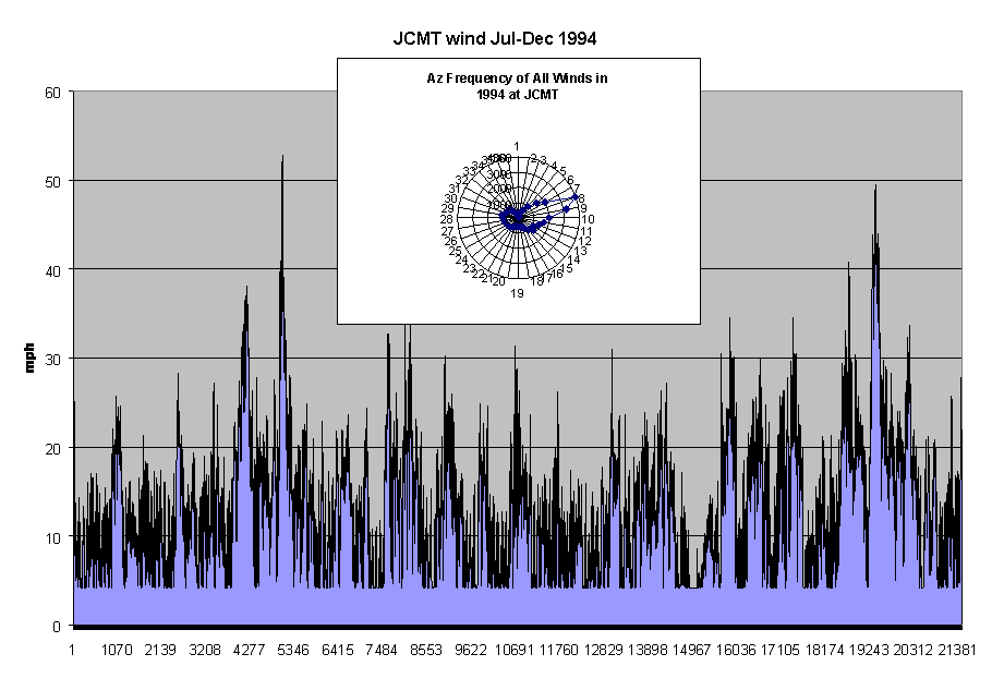
Not as much can be deduced from the wind data as from the thermal data. The reason is that the winds on Mauna Kea are distinctly local due to the size of the nearby topology. We can expect the wind environment on the inner ring of antennas to be similar to the JCMT tower, but the wind at SMA foundations 20 or 19 will be of an entirely different character.
Chart 8,Chart 9,Chart 10,Chart 11, show a number of examples to illustrate the wind environment in MM Valley. The winds are obviously extremely variable. The highest 15 minute average wind recorded during the entire 3.5 year period was 76 mph on 24 February 1997. An investigation of the raw data indicated that the highest instantaneous reading during this time was 98 mph. A spot check of a number of other records indicated that, when the winds were very high, a minute by minute variation of plus/minus 20% was the norm. The lowest winds on the other hand show a variation in excess of plus/minus 50% over the 1-minute intervals.
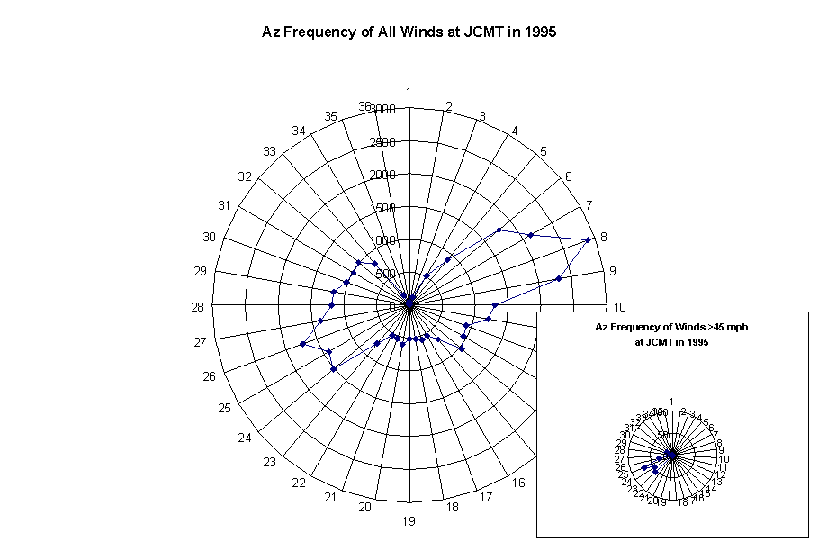
The highest winds tend to be accompanied by the lowest temperatures, for instance as illustrated on chart 8. When this condition is also accompanied by the highest humidity, it results in the severe icing conditions for which MK is well known. It is interesting to note, however, that these high winds tend to come from a specific direction, about azimuth 260 degrees. This is undoubtedly a local effect in MM valley, since you can clearly see the effect of the Subaru cinder cone on the wind azimuth. The more moderate winds will come predominately from two directions, azimuth 80 and azimuth 260. Again, we should draw no conclusions with regard to distant SMA antenna locations.
Water Vapor
It is interesting to try to combine the relative humidity and temperature data to infer something about the path length of precipitable water above the site, and hence the opacity. Although Moran (private communication) indicates that this comparison is reasonably successful at low elevation sites, this exercise appears to be futile on Mauna Kea. Using a report by Moran and Penfield¹, the column of precipitable water above the normal site (in mm) can be approximated by the formula:
L = 2650/(T+273) * RH/100 * 10^(7.5*T/(T+237.3))
Where L is in mm , T in degrees C and RH the relative humidity in percent. The formula assumes the scale height for the water vapor is equal to 2 Km.
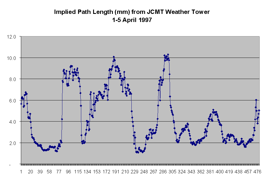
When this formula is applied to some of the raw JCMT data it is immediately apparent that the path length is overestimated, at least at the lowest values of RH. Few if any values of path length less than 1 mm are calculated, discrepant with the known opacities at the summit. Some of the reason for this discrepancy might be hinted by the humidity chart on Chart 5, which shows almost no readings on the JCMT humidity gauge below 20%. A few spot checks against the UKIRT humidity at the summit indicate that the JCMT gauge reads of the order of 80% higher at the lowest readings. It is possible, but not likely, that the conditions vary by that much on the average between the two sites.
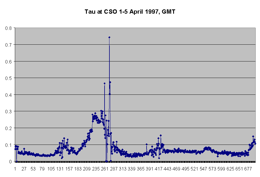
If a calibration of the hydrometer was the only problem, we could still glean significant data from the surface readings; however, a more telling point is that the scale height of the water vapor over the site is highly variable. Experienced observers suspect humidity bubbles only 10's of meters thick are floating over the summit (Ken Young, private communication). The presence of these low-thickness patches of water vapor can supported by these data. Note Chart 12 and Chart 13, showing the results of the above formula and the opacity as recorded by the NRAO 225GHz tipping radiometer for a five day period earlier this year. Large changes in surface humidity can go by almost unnoticed in the measurement of the total opacity. Thus, the lack of knowledge of the scale height appears to doom any calculation of opacity from the ground based data.
Acknowledgements
I would like to thank the JCMT staff for their help, especially Mary Fuka, who made this work practical by providing the 3.5 years of data in 15 minute averages.